Legend
 Inventory Boundary of Battle of Killiecrankie
All information on the battlefield has been copied from Historic Environment Scotland’s online portal on the Inventory of Historic Battlefields. For more information click here
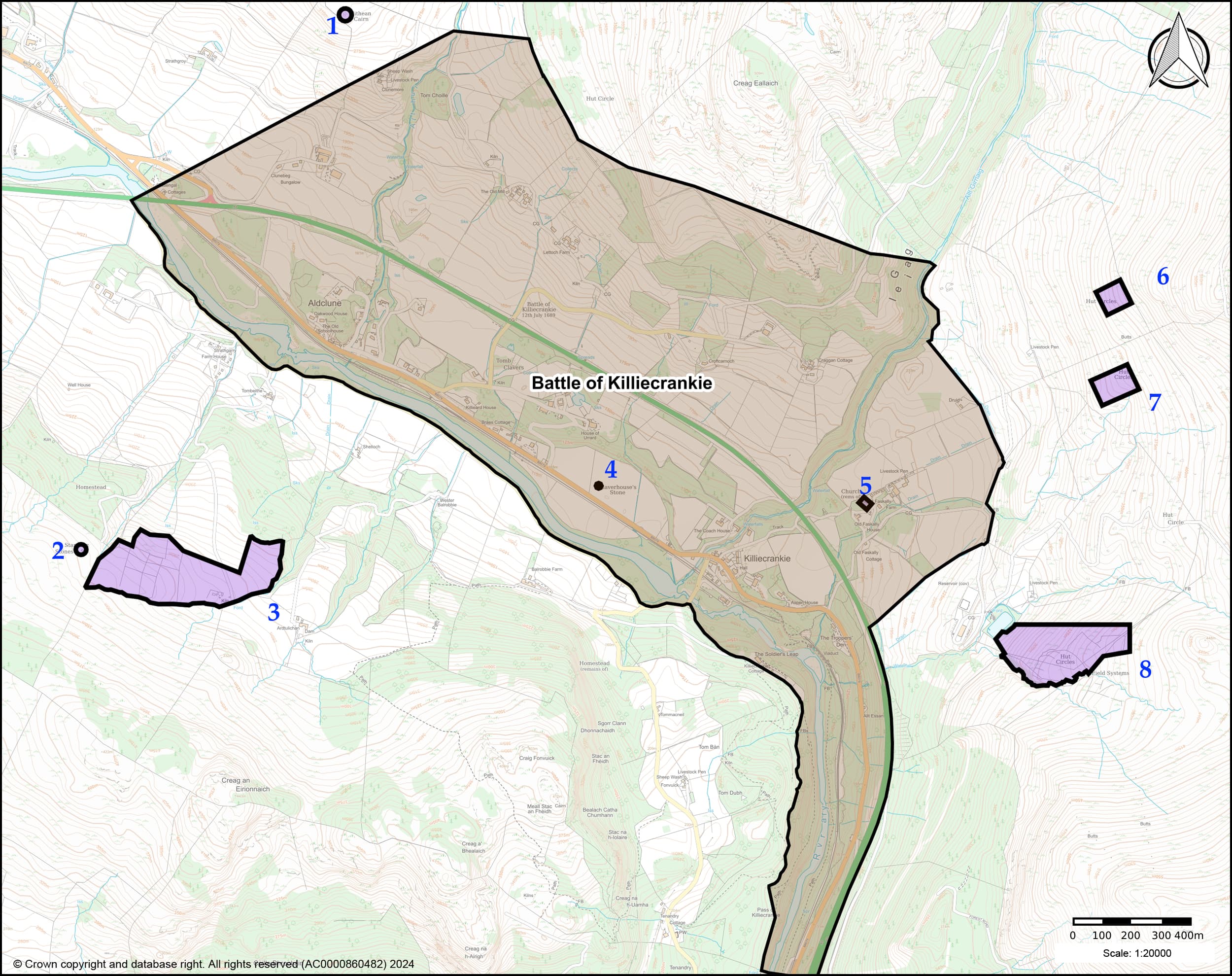
The Battle of Killiecrankie, 27 July 1689, is significant as it is the opening battle of the first Jacobite Rising in Scotland. In later years the success at Killiecrankie would be a continual inspiration to Jacobites in Scotland, even though the loss of their leader, ‘Bonnie Dundee’, in the battle fatally undermined their cause. It highlights the devastating effect a well-executed Highland Charge could have on an enemy and also displays the first of numerous technological and tactical developments by the fledgling British Army in this period. The Inventory boundary defines the area in which the main events of the battle are considered to have taken place (landscape context) and where associated physical remains and archaeological evidence occur or may be expected (specific qualities).
 Scheduled Monuments
All information on scheduled monuments has been copied from Historic Environment Scotland’s online portal.
For more information click here
1. Sithean Cairn
Prehistoric ritual and funerary: cairn
2. Standing stones 910m SW of Strathgarry Farm
Prehistoric ritual and funerary: standing stone
The monument comprises a group of four standing stones of prehistoric date, visible as an upstanding monument. The monument probably relates to ritual activity of Bronze Age date. It is of national importance because of its potential to contribute to an understanding of prehistoric ritual practices.
3. Baldornie, deserted settlement 330m WNW of Ardtulichan
Secular: settlement, including deserted, depopulated and townships
The monument comprises a depopulated settlement of post-medieval date. It consists of the abandoned farmstead of Baldornie, along with part of its associated infield system. The farmstead, as depicted on the Ordnance Survey First Edition map (1867), comprises one roofed building, five unroofed buildings, three enclosures and an unroofed circular structure. Three unroofed buildings, the remains of three other unroofed buildings and an unroofed circular structure annotated as a disused kiln are shown on the current edition of the OS 1:10000 map (1993). The field system consists of the partially dyked enclosure to the north and west of the farmstead, including a group of nine small enclosures 300m to the west. The monument is of national importance because of its potential to contribute to an understanding of post-medieval settlement and economy.
4. Claverhouse’s Stone, standing stone 200m S of Urrard House
Prehistoric ritual and funerary: standing stone
The monument comprises a standing stone of prehistoric date. Despite its traditional association with Claverhouse and the Battle of Killiecrankie the stone is likely to date to the Neolithic or Bronze Age periods. Such monuments formed a focal point for burial and ritual long after their initial emplacement. The monument is of national importance because of its potential to add to our understanding of Neolithic and Bronze Age ritual practice.
5. Church 100m WSW of Old Faskally Farm
Ecclesiastical: church
The monument comprises the remains of a rectangular church thought to be of medieval origin, of which all four walls survive to varying heights. Although probably largely of post-medieval construction in its present form, the existence of an aumbry in the north wall suggests the building is of medieval origin. The monument is of national importance because of its potential to contribute to an understanding of post-Reformation ecclesiastical architecture.
6. Settlement and field system 700m NE of Druid
Prehistoric domestic and defensive: field or field system
The monument is a settlement of the Later Bronze Age or Iron Age some 2000 to 3000 years old comprising the remains of three circular house stances set on artificial scoops dug into the hillside. They measure from 9m to 11m in diameter between wall centres. Below the settlement are the remains of a contemporary field system, comprising banks, lynchets and clearance heaps. The monument has very well preserved field characteristics. It is of national importance as a well preserved example of a settlement type more often found in the border counties than in northern areas. The settlement and cultivation remains have the potential to enhance considerably our understanding of prehistoric settlement and agricultural practices.
7. Settlement and cultivation remains 600m E of Druid
Prehistoric domestic and defensive: field or field system
The monument is a settlement of the Later Bronze Age or Iron Age some 2000 to 3000 years old. It comprises four scoops, each occupied by the remains of a circular stone house stance. The four stances lie in a line down the slope, and range in diameter from 11m to 12.5m. The four house stances are of national importance because of their well preserved field characteristics. It is likely that this unenclosed settlement on platforms represents occupation of the Later Bronze Age, comparable perhaps to the Unenclosed Platform Settlements found in the Border counties. A fifth house stance is of importance because it may represent an earlier phase of occupation.
8. Hut circles, enclosure and field system 900m SE of Old Faskally Farm
Prehistoric domestic and defensive: hut circle, roundhouse
The monuments comprise two hut circles, an enclosure and agricultural remains of prehistoric date, visible as upstanding features. Hut circle settlements are characteristic of the later Bronze and Iron Age periods and broadly date to the first millennium BC. They represent the remains of timber-roofed roundhouses with associated agricultural features.